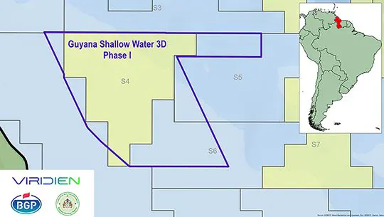
Viridien yesterday said that it has commenced Phase I of a 3D seismic acquisition and imaging programme offshore Guyana based on an agreement with the Ministry of Natural Resources.
A release from the company said that Phase I will cover shallow water acreage across Lot 3 and connect to legacy surveys in the area that will later be reimaged. For the project, the seismic data will be acquired by BGP, and Viridien will deliver high-end imaging using its proprietary advanced workflows.
Dechun Lin, Head of Earth Data, Viridien, said: “Our Guyana program is designed to enhance subsurface understanding, support future exploration planning and help unlock the hydrocarbon potential of this exciting frontier basin. The resulting ultramodern 3D data set will also make a valuable contribution to Guyana’s broader geological knowledge base and future licensing efforts.”
On June 30 this year Representatives of Latitude Energy Inc., Shearwater Geoservices and Future Energy Partners met with Minister of Natural Resources, Vickram Bharrat and team, to provide updates on the 3D Multi-client seismic survey offshore Guyana.
On March 9th this year, the ministry announced the advancement of seismic data acquisition for a vast swathe offshore in a move to enable further oil and gas exploration.
In a release, the ministry said that the 3D Multi-Client Seismic Acquisition is being supported by Viridien following an international procurement process that began on September 6, 2024.
This partnership represents a major step in strengthening Guyana’s offshore petroleum framework and advancing the modernisation of the energy sector, the ministry stated then.
Viridien (formerly CGG Services (US) Inc.) and the Government of Guyana have maintained a working relationship since 2010, during which the company has been responsible for acquiring, processing and managing the country’s seismic data. This new agreement continues a long-standing partnership.
The release said that Viridien is a global advanced technology and Earth data company specialising in geoscience, subsurface imaging and high-performance computing for energy, mining and environmental sectors. The company has decades of experience in seismic acquisition and processing and is one of the foremost global experts in the field.
The 3D seismic survey is an advanced geophysical method that uses sound waves to create detailed, three-dimensional, high-resolution images of the earth’s subsurface, primarily used for mapping geological structures, identifying oil and gas deposits and optimising drilling, the ministry added.










Discussion